Dempster Highway
Intro
Fair warning; We did not initially intend to drive the entirety of the Dempster Highway. This detour started on a whim as my sister and I we’re driving from Anchorage, AK to San Diego, CA. She had just wrapped up a seasonal position as a kayak guide and I came along for the ride as she made her way back down the west coast.
We started out wanting to drive up from Dawson City, YT to Tombstone Territorial Park to camp for the night. After staying the night at the park, we drove north towards Two Moose Lake (our initial final destination). We continued on the road a bit longer and after a brief encounter with a fellow Subaru driver making the return trip from Tuktoyaktuk, we found out that all services stations were still up and running for the season and the road conditions were prime to make the drive. We decided to give it a go and head north!
GEAR
Even though this trip was not gear intensive, It’s probably good to mention some of the essentials.
TRANSPORTATION
- 2016 Subaru Forester
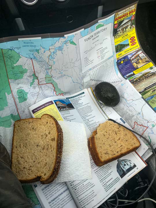
- Nat Geo Road Atlas – Adventure Edition
- Spare Tires
CLOTHING & CAMPING
Logistics
VEHICLE
While you may be able to get away with a 2 wheel drive vehicle I would highly recommend having something 4×4 or AWD. There’s no substitute for having four tires spinning while your trying to navigate potholes, ice, mud, etc.
SPARE TIRES
If you’re going down the Dempster, make sure you have a spare tire (preferably two and at least one full-sized). We blew two tires along the way, one just after Fort McPhearson, and one on the return trip near Tombstone Territorial Park. We only had a dummy tire which could have been a real issue had we not been near a service station each time we got a flat.
SLEEPING
Since we did this trip in September most of the campgrounds were closed. We ended up sleeping in the car at various pull outs and a closed-for-the-season campground. I would highly recommend looking up some primary and alternative options for where you want to spend the night. There are not many places along the road.
COST
Nothing is cheap on the Dempster Highway including gas and food. Plan accordingly 🙂
SERVICE STATIONS
There are only 4 service stations along the entire route (Eagle Plains, Fort Mcpherson, Inuvik and Tuktoyaktuk) and while they’re not too far apart, it pays off to double check that your vehicle can make it from one point to the next without needing to refill. We frequently didn’t see other travellers for hours at a time. It would have been a bummer to be stranded out on the road not knowing when a car was going to pass. Dawson City, YT to Eagle Plains, YT (252 MI) Eagle Plains, YT to Fort McPhearson (113 MI) Fort McPhearson to Inuvik (115 MI) Inuvik to Tuktoyaktuk (92 MI)
WATER
Bring plenty of water. I’m a bit paranoid about having enough water. When in doubt bring double what you think you will need, you’ll never be sorry you did.
TIME OF THE YEAR
We did this trip September. It’s not the most popular time of year to be on the road since the weather can be unpredictable. Fortunately, we lucked out and only hit one patch of weather as we passed into the northwest territories.
WARMTH
The nights dipped well into the 20s and I was stoked to have 0 degree rated sleeping bag to keep me toasty warm.
Stop-by-stop trip report
DAY 1
Dawson to Tombstone (69 miles)
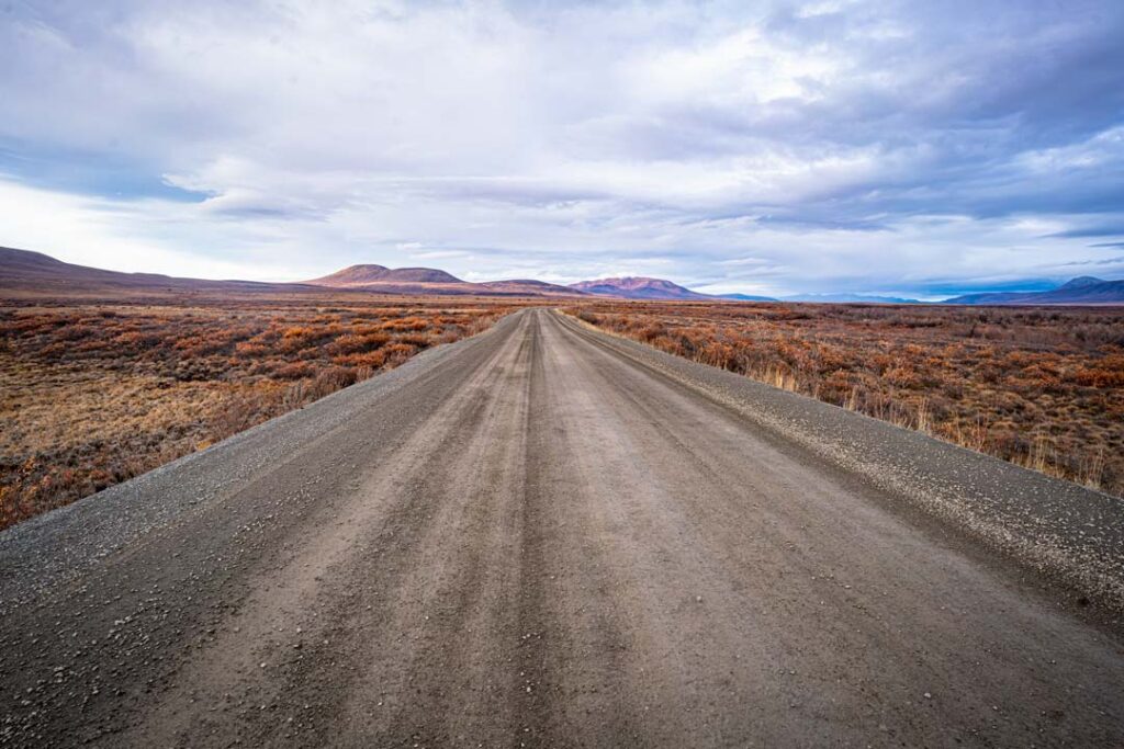
Shrouded in dense arctic evergreens, this section of the drive is a great intro to what the road conditions will be like the rest of the trip. Get used to the constant avoiding of potholes and unpredictable weather.
We made great time up to Tombstone Territorial Park and were stoked to find the campsites not even half way full. We set up our tent, made a fire for the night, and looked up to try and catch a glimpse of the northern lights.
Day 2
Tombstone to Eagle Plains (183 miles)
This section of the drive is actually some of the most interesting terrain we went through. The road winds through a mixture of arctic tundra surrounded by rocky cliffs and the Ogilvie River is stained Yellow from mineral rich soil surrounding the area. There were a few campgrounds in this section but most we’re shut down for the season.
It became pretty clear once we arrived in Eagle Plains that there wasn’t too much going on here. It is essentially a truck stop with an old 70s style motel attached. Great for filling up gas but I wouldn’t stay here unless you absolutely have to.
Eagle plains to Fort McPhearson (113 miles)
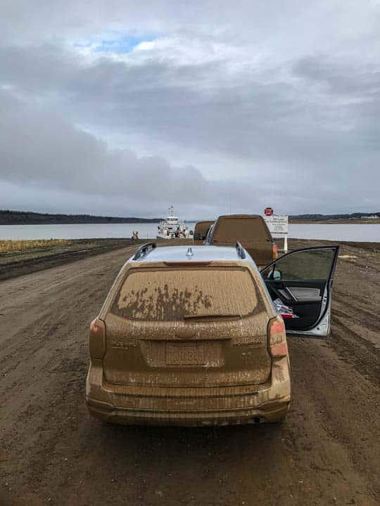
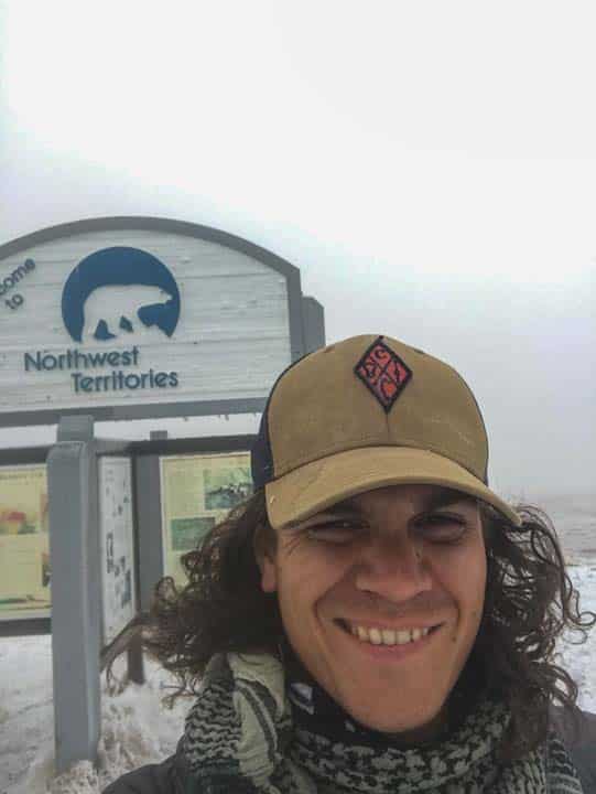
The true wild expanse of the area became clear as we drove this section. Rolling hills go on forever with patches of fire scorched trees marking where extensive wildfires had broken out. One of the best stops on this part of the road was a sign denoting that you are on the 66th parallel (the arctic circle). This stretch also held the worst weather, with snow falling on us, as we traveled up and over a mountain pass into the Northwest Territories. We continued rolling on through the hills and arctic tundra until we reached the first river crossing at Fort McPherson. All the ferries on the road are free courtesy of the Canadian Government. It was a great reason to stop and get out of the car for a quick stretch.
Fort McPhearson is the first “real” town you come to on the road. Despite some modern improvements, it’s apparent that the Gwich’in people here maintain traditional practices of hunting, fishing and living off the land.
After filling gas at the service station, we continued on down the road for about 10 miles before disaster struck! This was our first blown tire of the trip. We unpacked the car to access the spare tire in what may have been the longest tire change process I’ve ever gone through. Since our spare tire was only a temporary tire, we made our way back to Fort McPhearson. By that time, all of the local businesses were closed and we were forced to find a place to camp until the local tire repair shop opened in the morning. We ended up finding a closed campground with an open gate. Not sure if it was entirely okay to stay there but no one bothered us the entire night.
DAY 3
Fort Mcphearson to Inuvik ( 114 Miles)
In the morning, we headed over to the tire repair shop called LJs. They could have told us it was $300 for this simple fix and there was honestly nothing we could have done. However ,the staff was incredibly friendly, and the service was only 30 dollars. After a 45 minute wait, we started back down the dempster.
We took our second ferry ride to cross over the Mackenzie River and headed towards Inuvik. We stopped at Gwich’in Territorial Park which was great for a quick hike and some fantastic views. Once we reached Inuvik we were blown away by how large the town was. Over 3000 people live in this remote place. There are grocery stores, service stations, hotels and airports and more. We loaded up on some supplies and gas and continued North.
Inuvik to Tuktoyaktuk (92 miles)
We had no idea what to expect from this landscape, but from the map, it looked wild with ocean fed lakes and arctic tundra. We were not disappointed. As you wind through the newest part of the Dempster highway, you can see signs of people living in this remote place. Snowmobiles and hunting sleds are left scattered on the tundra. Groups of kids are out foraging for berries and small hunting parties were harvesting the meat from their latest kill. It’s a relatively quick drive until you reach the sign labeled “welcome to Tuktoyaktuk – Land of the Pingos”
Tuktoyaktuk was by far the highlight of this 570 mile one-way drive. After passing a canadian military installation, you arrive at the heart of this friendly Gwich’in village. Hardy snow ready dogs were in the front yard of every house and the local kids had a baseball game going in a park overlooking the arctic ocean. Pretty ideal!
If you’ve made it this far, no stop in Tuktoyaktuk would be complete without visiting Grandma’s Kitchen. Stop in and they’ll have a hot coffee and some Muk Tuk (bowhead whale blubber) made up for you in no time. The two proprietors were super friendly and gave us plenty of stories about arctic life. They even let us try on some local garb. We also took this opportunity to take a quick dip in the arctic ocean, because, why not?! As someone who loves throwing myself into chilly waters, this was an absolute highlight.
Tuktoyaktuk to Inuvik (92 miles)
We walked around the village and took in everything that was happening. After a few hours, it was time to head back. Heading out of town we could see a red fog-covered moon rising over this remote arctic village. We made it just past inuvik before pulling off to the side of the road and calling it quits for the night.
DAY 4
Inuvik to Dempster Highway Start (453 miles)
The route back seemed much faster than our original trip up. We took less stops but still made time to take some photos at Tombstone and Fort McPhearson. Our last bit of adventure on the Dempster was a blown tire just as we hit the Klondike Highway. Luckily a great NAPA auto parts was just down the road. They fixed up our tire and we were on our way down south.
Thoughts for next time
- Bring Spare Tires (full size)
- Research the route… we had next to no info on the trip. We also chose to forgo paying for cellular data which made getting information more difficult.
- Stay overnight in Tuktoyaktuk. This place was incredibly cool. Take time to dip your toes in the water or if you don’t mind freezing your ass off go for a full on polar plunge.
- Try not to drive at night. Avoiding potholes is a monumental task even in the day time.
Summary
If you have the chance to make this drive, DON’T THINK TWICE, just hop in your vehicle and go. This adventure up into the northern reaches of the Canadian arctic tundra is an unforgettable trip worth making. As mentioned, make sure to bring a good full-sized spare tire (two are better) and plenty of water, food and blankets in case you get stranded somewhere between service stations. Also, be sure to stop at Grandma’s Kitchen up in Tuktoyaktuk. It’s the best way to cap off a long 570 mile one-way drive. Looking back, this road trip is one of the strangest I’ve ever done, and well suited for those who want to ditch the pavement for something a little more exciting.
Did We Forget anything?
Let us know if you have any questions or are longing to find out more about the Dempster Highway. We’re happy to add to posts and answer any questions you have as you get ready for your epic Dempster Highway journey.